Introduction to the
YOSEMITE VALLEY
RAILROAD
Clayton J. Guest
The Yosemite Valley Railroad Company was incorporated in San
Francisco, California on December 18, 1902. John S. Drum along
with William B. Bosley, Sydney M. Ehrman, Thomas Turner, and
Joseph D. Smith were named as directors. John Drum must have
been named the president of the company because he
controlled 980 shares, where the other had five shares each.
Each share was worth $1,000.00. Thomas Turner was appointed
Treasure of the new railroad.
The articles generally stated that the company was to
engage in and conduct the business of transportation of
passengers, express and freight of every kind for
compensation. It also, stated that the said business would
construct and maintain a standard gauge railroad. Also, the
articles contained the verbiage necessary for all railroad
and transportation enterprises.
In principle the articles declared the railway would
follow a route through eastern Merced county to a point in
Mariposa close to the western entrance to Yosemite National
Park.
The articles further declared the railroad would use
steam,
electric power, and any other practicable motive power.
At that time the director declared the capital stock of
the company would be $5,000,000.00 in gold coin of the
United States of America and that the number of shares would
be divided in 50,000, each of par value of one hundred
dollars.
The origin of the railroad was to be in the town of
Merced in the central Valley of California. The rails would be
laid in a north-easterly direction across the plains to the Merced river near
Snelling, there the river would be bridged and the rails would
then follow the Merced near its northern banks in an easterly
direction through Merced Falls toward the Yosemite Valley. The railroad would enter
the Merced Canyon and Mariposa county, approximately 30 miles from Merced, and would
weave along the river for 50 miles while clinging to the colorful and steep mountains
that formed the canyon. The rails would pass through the
Exchequer area, a site near one of the early banks in California.
The railroad would again cross the river at
Pleasant Valley and run on the southern banks until it was just
down stream from
the settlement known as Bagby where the rails would again cross
to the northern side of the river. The rails would continue from
Bagby to the western boundary of the Yosemite National Park.
 |
|
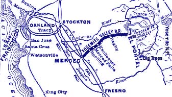
The above map shows the general location of
the Yosemite Valley Railroad within California.
Also, shows the connection to other railroads.
|
Colorful Names
Since a major portion of the railroad was built through the southern "gold fields" the forty-niners had prospected, some of the creeks and canyons were given colorful names by the gold seekers. Here are some of those names: Jones Flat, Temperence Creek, Hell's Hollow, Pine Canon, Humbug Gulch, Nameless Gulch, Flyaway Creek, Drunken Gulch, Quartz Mountain Gulch, Good Gulch and Sweetwater Creek. Those places were all in Mariposa County. In Merced County the rails crossed the Black Rascal Creek just a few miles east of the town of Merced. At milepost 14.7 the community of Hopeton, originaly ment Forlorned Hope, another unique name. |